Description(s) of "GUTH Venus"
( by; Brad Guth / IEIS updated February 26, 2003 )
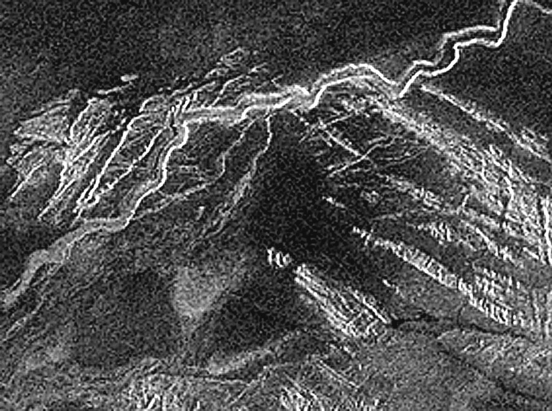
In spite of what Club NASA and a whole lot of their moderated wizards state, having been re-affirming for over two years onto their colleagues, as their being absolutely firm regarding that which is simply in their words, "NOT there to be seen", here is my ongoing tit for tat (favor returning and/or somewhat spiteful but I believe sufficiently true none the less) description of what others and myself (still sufficiently sighted individuals) believe is clearly apparent to be seen in the above and of all the following images, including: "mgn-72apd", "GUTH-72W-info", "mgn-72apd-info",
guth-venus-180-A","
guth-venus-180-info", plus so many other enlargements and further ongoing descriptions at http://geocities.com/bradguth
Plus my backup URL: http://guthvenus.tripod.com
In every instance I've offered my observational point of view but, I've also requested others to provide their expertise. What I've received so far is pure flak, absolute obsessive protectionism towards supporting their status quo, which just so happens to be a load of disinformation intended to support what's already on the books. Perhaps NASA's books were published by a subdivision of Arthur Andersen, which would certainly account for what's been going on.
Guess what folks; I've got us a another live one, as one serious Borg mole that's obviously closely tied into worshiping NASA's past and ongoing ruse. This time it's Wizard David K. and his very own Primo Astronomy Club, Inc., has offered some fairly new to me and entirely worthy insights into these Magellan images, scale for one thing and, otherwise absolute loads into entirely common yet oddly undocumented tectonics as having massively horizontal (2+km gap jumping) self suspension bridging lava forming activities that's become rather creative (sort of anti-gravity, but entirely common none the less), as in his experienced view of somehow offering entirely rational geometric's along with symmetrically rational shapes and alignments to boot, that which are all somehow entirely created by common natural events. Apparently, according to this David wizard, every Magellan image has it's superior counterpart that offers 9 times greater detail and thereby 9 times greater resolution (these much higher resolution images are obviously being withheld, perhaps because they're simply too revealing). As wizard David K. recently affirms, the publicly available GFI/TIF/JPG formats are not worth JACK and furthermore, that any perceptions improved upon by the SAR imaging being acquired at 43° perspective is also of meaningless value because, anyone knows that 2D imaging can only reveal 2D/flat information, irregardless of any near 3D perspective or 8-bit depth of content and/or of whatever composition attributes, as all of that being further associated with all their natural surroundings of rock, soil, erosion and quite possibly even a lava rille or two.
Presumably NASA has intentionally withheld this greater imaging resolution (easily computer converted into GIF format) for our own good because, too much of a good thing might impede their abilities as to obtaining additional funding. God forbid, should there be anything the least bit artificial contained within these very old Magellan images, as what would they do next, especially with all the hundreds of billions of new dollars flowing in and, focusing towards a planet that's so close at times it's damn near appearing a 3.5% the size of our moon (at least the dark side facing Earth at 0.27AU, that's certainly damn close, as in merely 105 times as far away as our moon).
Please do try to remember; I am merely utilizing my somewhat limited resources, in other words "zilch" (to be further understanding, I started off with merely 3.5 brain cells and becauce of my having to take all this warm an fuzzy flak, I'm now down to 3), along with fairly experienced Earthly photographic equipment, film processing and now digital expertise, as well as being personally experienced in radar teechnology and of the visual perceptions of what such an aerial perspective view of such obviously large structures appear to exist (in spite of whatever official "spin" and "damage control"), as well as to my best efforts towards a little (or what the heck, a lot of) freelance interpretation as to how these strikingly artificial considerations may have been utilized and, you should further appreciate that I am only having to accommodate this descriptive effort because, our infamous NASA seemingly has demonstrated (on several occasions) their total disregard as to realizing the greater of possibilities, which others and I feel this discovery so deserves (being that Venus is or at least was alive, this is sort of like your having to investigate the flawed logic or total lack thereof any logic as regarding the removal of the asbestos component from those Challenger "O" rings, or perhaps something like "Duh" on steroids).
OOPS; there I go again. I said something potentially negative about our Club NASA and, I didn't even obtain their permission prior to posting this document. Boy, am I in trouble now. Of course, now that I've broken rules 1 thru 10 and counting, I guess I have nothing much further to lose, so I might as well continue.
Should you desire to better understand SAR imaging from another (most any other) source, merely entering a search as for "SAR images", you will soon acquire more competent input then you ever thought was possible and, certainly more then you will ever need to know (especially if you're reading what other then NASA has to say about such). I do honestly believe this; If I were NASA and, if I had simply screwed up this thoroughly, by having overlooked such an entirely worthy discovery (belated 13 years worth and counting), and then failed further by otherwise subsequently applying loads of official disinformation as in "damage control" tactics, I would have to guess, I too would be doing the exact very same thing (stone walling until hell freezes over and/or those cows come home).
Guess what folks? I just checked again; Hell is freezing over plus, about those NASA cows; it seems someone snuck out one evening, killed them cows and then consumed all the evidence, so those cows are never coming home.
Since I'm always having my difficulty with words, syntax and composition; Another one of my description efforts, which simply might read a little somewhat better, is provided within the latter portion of yet another ongoing document: Guth-Venus-03 and, then be sure that you revisit my "flying Metro-Air-Venus", as this somewhat more recent discovery aspect is seriously becoming a tad bit more realistic by the day (I've even acquired some actual NASA type support that upholds this potential airship capability along with CO2-->CO/O2 as for energy resolving issues towards powering the damn thing). And, don't miss out on the new and improved Venus suspension bridge consideration.
This following description effort was one of my earlier attempts, along with some recent updates. This page should at least start you along your way towards some understanding as to what's potentially at stake. And, by all means, if you do not happen to agree and/or believe you can offer a better understanding as to what can be identified or not at "GUTH Venus", please do not hesitate to offer your opinions. NASA will not bite if you simply wish to side with my efforts because, I also have somewhat of a growing understanding (sort of life insurance) as to what all the fuss (discovery opposition) is actually all about, such as those infamous Apollo missions and, trust me on this, at least in the best interest of NASA, they really do not want any public fight over something that could so easily focus the greater interest from the entire world, as to having any taste of what other I've uncovered, thereby, you should feel safe as long as you have been openly recorded as being supportive and not just representing another silent yet ticking bombshell worth of internal "nondisclosure" liability.
Naturally, all of this endeavor may have perfectly good exceptions by those already fearing loss of their employment and warm associations with their cloaking on behalf of NSA/DoD types, as well as towards avoiding any future project funding cuts, simply because of taking up a mere perception that's outside of NASA's internal policy. In which case, I can certainly understand your predicament by merely associating with my discovery and, I alone probably can't help to protect what's rightfully yours (such as your job, related benefits and project security and funding issues). However, if you would care to retain and forward whatever documentation as to whatever unjustified termination and/or of being in any way black-balled by the likes of NASA, such as by any result of that "nondisclosure" policy impact due to any association with the "GUTH Venus" discoveries, my legal support teams could likely turn that one into a certain windfall in your behalf. On the other hand, I truly believe the loss of whatever you may have had with NASA, that may soon pail by comparison to the "GUTH Venus" discovery benefits from subsequent exploration and privet enterprise expedition opportunities, of which you can become part of.
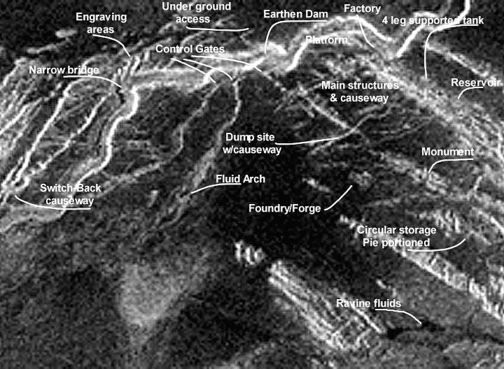
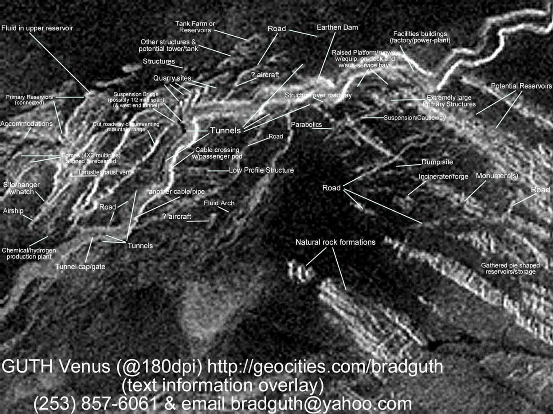
(for the sake of this following image review, please consider up as North);
Near the upper most area (just North of the major facilities/community but situated just below the main lava-flow channel/canyon) is an extremely long and flat surfaced tarmac like accommodating structure. Simply put, this issue alone is so totally out of place as to any other formations discovered on Venus, as this consideration is clearly indicating that of a rather significantly raised platform/runway, as an intentionally flat consideration amid those otherwise rugged mountains, having two or three logically shaped (if you will notice w/rounded bay corners) recessed service/storage bays, which further appear as adjoining underground accesses. This platform surface seems to offer some other structure(s) or perhaps other airship equipment as situated due East on the tarmac from what I perceive as an enormous flight deck elevator area (the darker upper left area of this enormous (potentially 7200+ foot) platform area is clearly somewhat rectangular and noticeably as well as sufficiently darker then that of the surrounding platform structure).
Directly South of this platform/runway consideration, are that of several large high-rise rectangular as well as some issues having rounded attributed along with vertical signatures (again; these considerations are unusually symmetrical issues as situated amid somewhat rugged mountains, steep cliffs as well as nearby extreme fluid like channel erosions) plus, as being along side and/or adjoining that of a rather substantial suspended causeway consideration (at either end of which having major facility structures showing fairly obvious entrance like and somewhat roof like features, perhaps including that of VAC equipment (that's obviously speaking of HVAC, except without the "H" factor, as who in the hell could ever possibly need heat on Venus).
West, near the edge of this image area, as situated just above that large primary channel or somewhat grand canyon, there certainly exist what could be and I think is most likely that of a massive airship, as seen protruding out from under a horizontal silo/hangar door or overhead hatch. Because of the compressed raw 75 meters/pixel format (even that calculation is being entirely conservative), the size of this airship is thereby something on the conservative order of 180 meters by 1200 meters. A bit more about how such an airship may play an important roll can be reviewed as follows: Air-Travel.htm and onto this next one classified as non-NASA approved because it includes a little humor: the-seasons.htm. The required buoyancy being previously explained; subsequently the next issue is that having to do about the required energy resources plus Vertical CO2 Wind Power and, perhaps this next twisted item of energy application conjecturing, as these energy issues would likely all become a requirement for our better understanding how such an airship should be further reviewed. Come on guys, your wizard like input is more then welcome.
Towards the left end of the main township causeway; there may in fact be that of your basic parabolic communication or at the very least of two massive solar collectors or possibly that of research/radar astronomy observation structures or possibly this may simply representing solar power conversion generators (sealed sterling type, exactly like those existing hydrogen filled sterling systems that have been in operation right here on Earth, except so much larger so as to compensate for all that thick cloud cover), plus adjoining the Western end of this causeway there is also to be seen a fairly long incline/decline, possibly representing a steep tramway or simply that which was constructed as a structural function as for supporting this massive suspension causeway. If these parabolics become communications issues, that makes perfect sense, so as to be in full duplex communications with "GUTH Venus-2 and GUTH Venus-3", both of sites which are at 180° and, would likely need just this sort of configuration if applying short wave radio propagation, of that which efficiently reflects off that thick cloud layer.
Below this large E/W causeway are several clearly definable structural features and/or large roadways, clearly representing that of further infrastructure, such as a fluid outflow or observation platform/ramp at the mid/center of a "U" shaped element.
Directly East of this main causeway, located just below and along side the main so called lava flow channel (as blocking/obstructing your view of the channel's bank) are relatively long structures that indicate some attributes on top, suggesting that this artificial formation could very well represent their factories or that of a CO2-->CO/O2 power generating plant.
In addition to the substantially large and obviously inner-connected reservoirs which can be clearly identified to the NW (situated well above the primary channel), of which I am estimating just these 5 clearly reservoir looking items contain something like 50 million cubic meters worth of whatever (that upper most reservoir indicates a dark center, as such it's containing something fluid). Onto the East and SE are many other storage/reservoir considerations (at least one seems clearly supported above ground) and, a bit further to the SE is quite possibly even that of a monument or two, and further South can be seen that of a substantial circular collection of pie-shaped reservoir/storage like elements (perhaps these are of somewhat older establishments).
To the SW is what I clearly view as an arch (be it extremely large and high and quite possibly or most likely that of a fluid consideration). This clearly looks as being an arch and not otherwise that of any known/recorded common formation and, it's obviously quite large, it is not otherwise any form of a SAR imaging shadow, as there is nothing in the greater image capable of reflecting nor causing such and nothing like it elsewhere, as it's simply too dark in relationship to it's surroundings to be of rock formation (you can even see through and under this arch), nor is this of any illusion as to having relationships to poor or badly reflected lighting (that's not even possible with respect to SAR imaging), my photo software certainly did nothing to create it or even embellish upon it (as it's clearly within the raw 1:1 image to begin with), and it is obviously of something strongly related to that distinctively eroded secondary channel, that which is coming directly down from and off the primary channel, which is clearly feeding it something fluid. Nothing like it shows itself elsewhere on Venus nor on any other planet (including Earth), so it's clearly an entirely new and certainly highly unusual discovery consideration, as possibly being entirely natural and/or potentially as contrived/embellished upon by those still living on Venus.
Due South of the main downtown causeway and assorted structures are what certainly appears as that of an extremely tall volcanic like vent (yet one that just happens to have it's own lessor causeway clearly crossing it) that which may indicate that this now may be utilized as their dump site or simply that of a mining operation and/or how about as for housing some of those vertical wind tunnel turbines (operating at 4+bar/km and 10+m/sec). Being nearby, as directly North, there are those obviously suspension/roadway issues traversing that ravine and/or pathway, as that which is clearly situated directly below the main E/W structured causeway.
Back at the (NASA's so called) main lava-flow channel, just to the left of the platform/runway, there appears an earthen dam has been established, along with a potential tunnel or discharge/gate as that potentially offering some form of passageway or flood/flow control feeding into the ravine which then routes directly under the main suspension causeway, where this runs SSE as to be flowing into an extremely deep ravine/terrain like area (perhaps that of several kilometer drop-off). The base of this ravine area is obviously exceptionally deep, where at this base could be holding certain fluids (aperture radar imaging records most fluids as dark [near black] clearly indicating a lack of radar signal reflection), and this deep valley/base is in fact being recorded as "black".
Above the main lava-flow channel, to the NW, I am considering this structural arrangement (situated within a rectangular clearing) as that also of a reservoir tank farm, and to the West (left side of this image and still above the channel) is what appears as there being a "switch-back" roadway having multiple hillside gouges (along with an assortment of mining and/or quarry reliefs) along side, plus I can clearly identify the not so narrow suspension bridge crossing that NASA so called lava-flow channel or massive lava rille, as situated at the NE end of this somewhat lessor roadway. This is a fairly substantial and long bridge at that, having an absorbing object/mass area or complex structural element (SAR absorbing consideration) at its midspan (this is a not so narrow of a suspension bridge, perhaps 75+ meters wide, and one that is obviously spanning the entire main channel of 1+km), and by the way folks, lava-flow channels are not likely to be flowing lava these days, and not that I'm all that convinced this primary channel was ever lava formed (this channel looks much like your basic fluid/water erosion to me).
Further south of this (not so narrow) bridge, I can perceive somewhat power distribution towers or perhaps that of a suspended pipeline or perhaps that representing suspension cable crossing like transportation terminations (as showing opposing structures on either bank of that massively wide and deep channel, and what also looks as there being at least two suspended passenger cable cars or pods), and then also that of a nearby lower profile yet substantially rectangular structure (situated within it's own clearing as having an obvious roadway access), as being a form of transport, mineral pumping or transmission termination station of some form, basically this is adjoining the Eastern bank of that primary canyon.
Remember; if you happen to live and work on Venus, it's probably fairly hot, even at this altitude, and most likely even still a bit toasty at night (becoming comfy for most Islamic lizard types). That thick and hot CO2 atmosphere might even be somewhat nasty if not downright acidic at that. Yourself as well as everyone else needs nearly full-time shelter, perhaps something underground or at least that as a significant number of structural surface housing that can maintain a suitably safe (obviously thermally insulated) environment, as well as equally protective ground transportation considerations, such as within channel crossing cable pods, sufficient roadways and a bridge that can handle fairly large transports including a train that could haul sufficiently protective rail passenger cars so as to shelter it's riders, and yes, hopefully considerable air transportation so that you and anyone else can simply get the hell out of town prior to sunrise, such as using the massive airship situated towards the West and just above the primary canyon is what others and I believe clearly looks and smells like a silo/hangar and, this is showing the nose of what could very well be an airframe of sorts. This is a fairly large and complex consideration worthy of your further study, as this issue may become critical to those on Venus.
Even though this initial description has been and perhaps should be considered an overwhelming amount of image interpretation, none the less, without obtaining the assistance from those supposedly more endowed and supposedly talented soles and, as so much time was simply wasting away, I felt there was simply no alternative, then also I felt the need to expedite because there is still so much more to be uncovered and time is not necessarily on our or their side, especially when all of this effort has been absolutely at no thanks to those supposedly more qualified within NASA/NSA/NIMA/DoD, as this image interpretive phase alone is ongoing and will require some time and perhaps further talent, none of which seems forthcoming via Club NASA. So, I'm simply doing and offering what I can, subsequently I have been discovering from others, that my many years of experience and capabilities are apparently not all that bad and certainly not all that far off. Meanwhile, Club NASA is getting their free ride, or so they think (perhaps little do they realize what's ahead).
If you should agree or not, please let others and myself know, and otherwise knock yourself out!, or simply send gobs of money (actually I'll more then make due on 1% of what ever NASA gets), just like you've been unwillingly or at least unknowingly donating such massive infusions into NASA/NSA/DoD for all these decades. Just be certain to put my name and address on that check and envelope, and I'll personally see that you get the most BANG! for your buck. With such added support, perhaps I can afford to deliver a little beneficial NASA ass kicking to boot (somebody has got to make those agency changes, as obviously those changes are not going to come from within NASA).
Return to GUTH Venus "index.html"
Copyright © 2000/2002 - Brad E. Guth
GUTH Venus: All Rights Reserved
Webmaster: Brad Guth -
BradGuth@yahoo.com
created: June 12, 2001
Brad Guth / IEIS IEIS-Brad@Juno.com