This bridge (natural or otherwise) exist by the obvious following facts:
First of all; We (including all those pro-NASA types that are still on hold for their NSA/DoD Borg implants) can clearly see the damn thing and secondly; there's no freaking way in all of holy hell of any natural tectonics nor gravity alluding lava on steroids accomplished this sort of grand rille or canyon jumping feat and, thirdly is the "extraordinary fact" that unlike anything imaged via film and even of the finest of CCD imaging, as far as this NSA spy SAR imaging format goes (especially multi-look of 8-bit depth as that acquired at the nearly 3D worth of 43 degrees perspective) does not lie. Unless you are unable or just thoroughly unwilling as to look out the window of your typical high flying rigid airship, as better yet to be utilizing that of our utmost proven spy technology of aerial imaging, that which far surpasses what any human eye can discriminate, then I'm not going to bother re-elaborating upon all of what the SAR imaging "extraordinary" qualifications are, nor that of my photo enlargement details, as I've more then provided this necessary level of research support and, if you still can't locate such support, just ask and I'll gladly point it out or re-summarize it and forward you a copy.
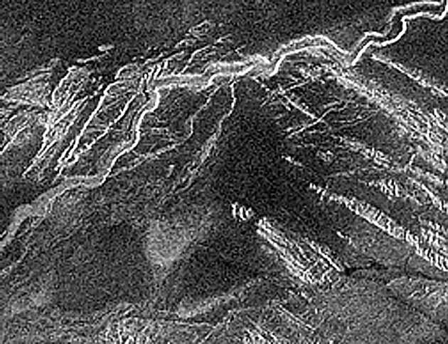
In actuallity, there's a forth significant factor, in that these 12+ alligned and being extremely horizontally flat pixel items are not orphans, as there's an associated road or rail bed that's clearly circumventing a rather significant mountain range, along the way having signs of large excavations and as just above the the NW end of this bridge are clear indications of multiple rectangular rock quarry sites. I'm also detecting several nearby tunnel like features
I'll concede, if this very artificial looking attribute were of the one and only such issue to contend with (like that pathetic "Mars face"), then I might be having a wee bit of a difficult time of it. But folks, it's not even representing 10% worth of pixel count as compared to so many other far more complex and even somewhat larger artificial worthy attributes, such as what's comprising that massive tarmac. By using the term of "more complex", I do mean as entirely and significantly different and thus entirely out of place as compared to the surrounding territory (that's besides the fact that we have nothing on recorded on Earth of any purely natural formation that comes remotely close to this stature), as in offering such a highly regular alignment and of such straight (unarched) comformity instead of your typically and expectedly random/irregular natural surface features, that are surrounding this bridge as well as indicating beneith it and, even more so is by way of this bridge representing a significantly symmetrical geometry as any such unified feature ever gets.
Including a fair number of nearby items, those of unusually vertical and otherwise entirely as unnatural vertical as well as of various unexpected horizontal attributes and, that's not even the end of it, as there are a few nearby associated issues involving curves and of round like items, such as parabolics and of reservoirs, which are equally as entirely out of character with respect to their natural surrounding territory, even with respect to any known geological features of greater Venus or, how about for that matter, of any moon or other planet, including Earth.
This one relatively insignificant bridge consideration of extremely horizontal pixels may not even represent 1% of the total pixel count upon all the remaining other items, of those that are more likely than not being represented as artificial in my book, along with combining other issues are what I believe is clearly creating an entirely rational community or industrial site like setting. If I or anyone (typically a pro-NASA critic of anything that's not been sanctioned by NASA) could locate the least bit similar, as for example of any bridge feature spanning such a broad rille or canyon or even that of a large ditch, as being confirmed as representing any common planetary tectonic or lava formed feature, thereby proving as such being purely natural due to the evidence of sufficient surrounding circumstances, of there being the sort of local tectonics and/or lava flows which can be in any way identified as creating such a straight bridging attribute, then once again folks and critics, even if that image/proof were obtained of something Earth, I would be having a thoroughly bad time at my stipulating otherwise.
Clearly it's not that you and I don't have a fairly good number of such pre-qualified SAR imaging examples to draw from, as within such examples are in fact a great number depicting smaller and larger occurrences of fairly respectable horizontal objects spanning rilles, canyons and even open water, as I'm certain you and I do have such Earthly SAR imaging examples, perhaps tonnes of them except, that in every such imaged example horizontal attributes are those clearly being artificial (man made or in the case of NASA, perhaps they're illusions because, such occurrences as created by anything the least bit natural don't seem to even exist on Earth) attributes as having multiple other associated items or rational logic associated, like that of a rather complex roadbed and/or a most likely tunnel, then of something and/or a whole lot of nearby other considerations that clearly represents a number of worthy other artificial structures, offering the community infrastructure associated with just this sort of bridge application, not to mention the rather obvious switch-back of that roadbed which seems to defy the laws of gravity, as I rather doubt there's been any recorded tectonics and/or lava flows that serpentine out of their way in order to circumvent a rugid mountain range.
As aerial imaging goes; Your typical "plan view" (looking nearly straight down) would not have shown this feature nearly as well, perhaps not at all. A typical CCD image (exactly like those being acquired from Mars and, if obviously having been acquired from below those thick Venus clouds and even if at much closer range) could easily have missed this feature altogether because of lens/optical limitations, lesser perspective along with whatever atmospheric distortions, insufficient contrast and/or just piss poor results due to such poor lighting issues, nearly exactly like all of those Apollo ruse images (unfortunately none of those negatory issues applies to SAR imaging, especially as that being acquired at 43 degree perspective and/or as to be offering the 8-bit composition worthy considerations to boot). But then of course, unlike like Sgt. Schultz� and Col. Wilhelm Klink, as an official image observer you actually must be capable of sight (irregardless of your "G" whatever rating, as white canes and dogs simply don't count).
Guess what folks; Once again I've got us another live one (an official NASA Borg drone or "spin" and "damage control" mole), as an individual obviously closely tied or obsessed into worshiping NASA's past as well as NSA/DoD's past along with their current ongoing aftermath of 9/11 or bust. This Borg I'll refer to as Wizard David and of his very own "Presumptuous Astronomy Club". Wizard David has offered some fairly new to me and entirely worthy insights into these Magellan images, scale factors for one thing (everything being so much larger according to his information, where this large factor alone is somehow an automatic disqualifier according to his superior expertise [I guess, we don't want to tell Wizard David about ants because, everything they build is simply too damn small]) and, otherwise loads of other most interesting insights into entirely undocumented tectonics and of massive unsupported horizontal bridging lava activities that's somehow rather creative but otherwise according to Wizard David is to be found nowhere else but Venus, thoroughly creative lava as in offering assorted geometric's and then of symmetrically rational shapes to boot. For starters, you need to understand that initially this David guy refused to even acknowledge that the long and near white horizontal object associated with spanning his channel/rille even existed, in fact, according to David; it was not even there to be seen at all, so therefore, no such bridge consideration could even exist.
When I further attempted to refocus his failing vision onto the clearly long and horizontal and nearly white object (noting the continuation of the rille valley features are clearly flowing below that horizontal item and continuing on through to the other side or be that down stream of this large bridge like attribute) which being nearly white indicates something much harder and/or more massive and thereby more radar reflective then of the average surroundings of Venus rock and soil. Yet there's simply no pointing this one out because, he sees absolutely nothing that's not entirely/avbsolutely natural (sort of just like in Hogan's Heroes", like Sgt. Schultz� and Col. Wilhelm Klink whom continually "see nothing").
Apparently, according to Wizard David, every Magellan image has it's vastly superior counterpart that offers 9 times greater detail and thereby 9 times greater resolution (these higher resolution images are obviously being withheld or unprocessed because they're too revealing, as David is not even willing to share his supposedly superior imaging results that would somehow entirely prove his point). As Wizard David recently affirms, those publicly available GFI/TIF/JPG formats are apparently not worth JACK and furthermore, that any perceptions improved upon by the NSA technology of SAR imaging, such as those being acquired at the superb 43� perspective is also of meaningless value because, according to his vast superior knowledge and nearly instant/overnight expertise in such matters, anyone knows that a 2D image can only reveal 2D flat information, irregardless of any certified perspective or of any 8-bit depth upon content and/or capability which just happens to also include composition attributes is apparently worth only crap. For David's benefit, I'll pass that insight along to NIMA.MIL, so that they'll stop wasting those hundreds of millions from looking at their spy images, those acquired using this very same SAR imaging.
And, if size continually represents a magic disqualifier, then perhaps the size of David's brain needs to be surveyed because, that's obviously way too big and, therefore according to those very same pro-NASA standards of size being utilized against my discoveries, you don't exist. In the first place, I was never asking of size nor expecting to be the "all knowing" expert on size, as connecting the pixel dots has absolutely nothing whatsoever to do with size, as it has to do with intelligence, which obviously the majority of my critics have none.
Sorry if someone out there thinks I'm being a wee bit overly tough on such hard working opposing-everything individuals. I guess I'm just thoroughly sick and tired of my seeing so little accomplished for humanity, especially when such an enormous taxpayer investment has been taken and lots more seems yet to come (that includes many taxpayer funded institutions as well as the sort of arrogant individuals taking their fullest of tax credits for their pretentious astronomy so that the rest of us have to take up their slack), this being all that much worse when we have an almost too nearby planet such as Venus that's been knocking our doors down (at least every 18+ months), which just so happens to be offering a rather serious load of artificial worthy content to boot.
Sorry again, that I may have forgotten, some of you fools must actually think that by the use of the word or phrase containing "artificial" you must actually believe that somehow this is something phony or of a pure contrivance. Well folks, artificial is certainly anything but natural and, if it's considered as artificial, that clearly means that someone other put it there. That's another "duh!" for those that still can't figure out how to get the first sheets of toilet paper off the role.
OK, presumably NASA and now the likes of Wizard David has for some unknown reason intentionally withheld this supposedly greater imaging resolution (too much bother, as this opposing guy stated, as for them easily converted into GIF or whatever format) apparently because, too much of a good thing might impede their abilities as to obtaining additional funding for their bogus research. Perhaps God forbid, should there be anything the least bit artificial contained within any of these Magellan images, as what would these fools do next, especially with all the hundreds of billions of new legitimate research and exploration dollars and, as applied towards a planet that's so close at times it's damn near appearing as 3.5% the size of what you or I view as our moon and, somewhat better vantage yet as from Earth's L1 point (at least to an astronomer viewing the dark side of Venus as facing Earth at 0.27 AU, that's really damn close, as being merely 105 times as far as our moon) and, if my math is only somewhat correct and I've managed to get half the syntax of all this across, viewing Venus from EL1 can be something way more capable yet, as like representing 11+% lunar size as either object being viewed as from Earth's L1 SOHO solar monitoring satellite or, how about a target that's nearly 3.25% as compared to that of the sun. For this sort of target viewing you actually don't even need any stinking telescope, as you and I can see certain details within any 3.5% lunar area, you only might need a telescope or some other apparatus so as to effectively block out the sun, thus with such a relatively small or limited telescope, one could easily identify if there were to be anything illuminating, as in emitting packets of Venus lizard smut might so indicate.
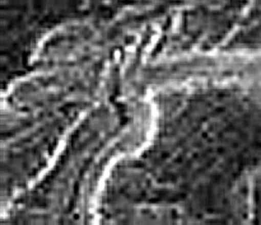
In the above image; as according to proper NASA Borg like individuals, I alone (which means; you either can't or are simply not allowed to see anything) can clearly identify this as a horizontal consideration as not such a narrow nor short suspension bridge that's crossing that NASA so called lava-flow created channel or perhaps rille as David calls it, as that being situated at the North Eastern end of a somewhat complex/contour following mountain range circumventing roadway. This bridge consideration is a fairly substantial and long bridge attribute at that, having a somewhat darker (less radar reflective) object/mass area or structural midspan cluster element (by that I mean; an obvious SAR signal absorbing consideration, sort of like what a massive cluster of tension cables or perhaps a composite mid-span structure might generate). This is not such a narrow suspension bridge, most likely 75+ meters wide, and one that is obviously spanning that entire main channel of 1+km to as much as 1.25 km (here again, Wizard David wants this overall calculation to become 2.25 to as much as 2.5 km wide) as when that's based upon the raw meters/pixel count and including the bridge landing. And by the way folks; even though Venus currently has a number og active volcanic signatures (as an energy resource that's sorely missing from anything Mars), even if this channel were such a lava formed canyon or rille, such a channel is not likely to be flowing lava these days (since any massive thermal signature of active lava would have been easily recorded as such), not that I'm all that convinced this primary channel was ever lava formed, as this geological feature looks much like your basic fluid/water erosion to me (possibly mud or even H2O2 or for many opponents this fluid would have to be pure H2SO4), but then I'm being continually informed by my esteemed critics to entirely disregard what I can see because, it simply does not exist, at least none of it exist as long as there's anything potentially artificial associated.
So, perhaps we need to accept that this entire channel is equally nonexistent because, there are certainly a good many smaller details as pertaining to this channel, those which I would have only considered as being entirely natural, however, if this bridge issue is entirely nonexistent as being anything artificial, then most certainly all of those smaller then bridge features do not exist either, which then must openly represent that the entire channel is just another one of a kind illusion (at least that's been what Club NASA and the likes of Wizard David might want you and I to believe).
Backing yourself off from this image, zoom out if need be, all they way to the NASA original; seems to be indicating that this channel and it's somewhat long and I call it grand canyon like features do however seem to exist (rugged mountain ranges, tectonics and lengthly erosion with an enormous lake basin up the kazoo). Zooming back in and applying certified resampling photo filters also seems to remain everything faithful, as yet indicating this very same rugged channel, along with representing a whole lot better detail of it (as being undistorted and unaltered). So, if all these smaller then bridge natural details still do not exist in your book of truths, then perhaps the entire channel itself does not exist and thereby perhaps the entire planet of Venus (because it's certainly too big) is equally nonexistent, at least that's exactly what my opponents and their official NASA record have to say of my discovery, as their opposition is not otherwise about to offer one positive consideration, especially if that might improve something for humanity, least of all if there's not an apparent risk factor as compared to their preferences for acquiring and returning those potentially lethal microbes from Mars.
NASA/NSA/DoD and even their superior counter parts of NIMA have had there opportunities for more then two years, of course, these are the very same wizards (like Sgt. Schultz� and Col. Wilhelm Klink) that can't ever see those Earth killer space rocks until they've hopefully passed by Earth, that's including some dozen or so every year as being really big mothers (100+ meter) some of those zipping by Earth at something under 100,000 km/hr (NASA's newest slogans; "better late then never" and perhaps just exactly like our pathetic space race ("better dead then red"), where these nifty space rock encounters could actually offer some of us a truly warm and fuzzy feeling, especially if you're anywhere near ground zero of one of those megaton rocks as it's making an unscheduled pitstop on Earth).
OK, so NASA has been totally braille and otherwise most astronomy sucks; To myself and for those having yet an open honest mind and, still the raw ability to actually see what's there to be seen (not just what Lord NASA and their moles and Borgs want you to see or not), this simple bridge issue is not even the least bit of greater size nor complexity of being all that outstanding in my book, at least not as compared to so many other artificial worthy considerations associated with the "GUTH Venus" sites, yet it's more then apparent existence and highly rational placement and more rational yet associations to other aspects of the nearby community seems a wee bit more then good enough, as to being worth focusing our attentions upon.
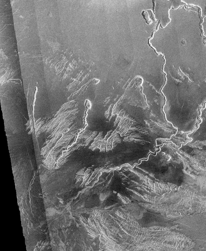
To add a little further insult to this injury; besides the SAR detection of something fluid like as existing static within that upper NW reservoir, there's yet another curious fluid worthy issue just South of the rille/canyon, as representing an active fluid arch, a very substantial arch at that, having clearly defined initial ejection erosion and subsequent impact or destination erosion where this fluid arch contacts the ground, a point which is clearly situated on a steep bank or terrain hill side and well below the start of this arch. It's apparent SAR density is that consistent with being fluid and/or moving, such as would be (by SAR standards) indicating something that's most likely fluid, possibly mud like. Again folks, I believe this is not likely volcanic, as thermal signatures would have been off the scale. What I'm hoping is, this is more likely consistent with a flow of mud, H2O2, H2SO4 or perhaps somewhat more likely petrol/chemical (either of which substances can safely exist at the temperature and pressure). Obviously this arch was comprised of a good many raw pixels (far more then of the bridge), as are the sizable in/out erosions or cavities associated with the arch. The photo software did not even have to work all that hard upon enlarging this feature, as others and I could roughly discriminate this arched feature within the 1:1 raw image. This natural geological feature is also confirmed as not an SAR fault nor illusion, as the surrounding terrain and quite Venus like large and smaller rock formations are those seemingly not being the least bit bent or in any manner whatsoever distorted nor being otherwise assembled into geometrical/symmetrical formations, especially not that of any damn arch. So, this individual arch is not any fluke, not an imaging error but more likely than not it's WYSIWYG (what you see is what you get).
The nearby associated roadbed is also not anything so easily lava formed, unless gravity was nonexistent during much of the flow period, even then the "switch back" and all those "excavations" along the way (I'm not even addressing any of those other massive rectangular quarry sites to the North) need to be explained. Another explanation will be needed as to why this roadbed (if purely lava/tectonic/erosion formed) didn't just drop itself off at several instances into the adjacent canyon, instead there seems to have been a long running concerted and responsible effort at keeping that from happening plus, it's having to deal with a solid rock/mountain like obstruction which may have needed a tunnel through it, that is of course, if this roadbed were to be properly associated with any such suspension bridge. I'm not exactly certain of this tunnel issue but (it could be just another area of excavation or blown out relief), I do believe I can sufficiently ascertain or establish (from looking at this imaged terrain) that just such a tunnel or relief attribute must exist, as that associated with the Western landing of the bridge. As otherwise, what's the freaking point of their constructing such a complex and wide span capable bridge, as to having that road circumventing such a significant mountain range, as clearly these two issues are preferable as to either being aligned with each other if not rationally associated with each other. Lets see, perhaps this is a whole lot more then just a little obvious, where "road" and "bridge" makes this one into a double duh!
If you simply can't bring yourself to accepting the image as proof of bridge, proof of road, then certainly you and I can prove it's nothing naturally formed. Going by the entire NASA or that of any other database of such potential geology formations, of anything similar on Venus or Earth or any other planet or moon, there is yet nothing whatsoever on record that even comes close to spanning anything like this canyon/rille. There are simply no such recorded horizontal gap leaping, gravity alluding lava flow events nor even of any speculated lava and/or tectonics that could explain how something purely natural would have simply flowed irregardless of terrain and gravity in order for lava to initially circumvent a fairly substantial and rugged mountain range, then horizontally launch itself in order to effectively span such a grand canyon/rille of 1+km. Any such bridge formation that could have remained by erosion on such a grand scale, as depicting no significant arch, I seriously doubt this degree of natural could be anything realistic, at least nothing is on record towards supporting that argument, nor are there even hypothetical equations that could apply. Remembering that this SAR 8-bit image was acquired at 43 degrees, nearly 3D ideal as for ascertaining contour and depth issues (such as for looking directly under that bridge) and, all that's in addition to content and substance issues. I've searched a great deal of other images, but even I'm not the one saying that somewhere out there is not an example, just that my best critics can't be bothered with looking that one up, perhaps that's because there's such an unlikely existence and, so much so that even all of my efforts have come up empty. So, please help me out here folks; if this item is not a constructed bridge, then what the hell is it?
As you might have guessed; I've received countless replies of total outright disbelief, remarkably as based somehow purely upon the mere size of everything, as though somehow size has much of anything to do with what I'm describing (artificial looking patterns, big or small, are still artificial looking patterns). Ant farms build really small bridges, some fairly stupid humans build really big bridges and, even those Greeks and Roman's did a damn fine job of it until they ultimately realized they were so stupid that they all essentially but died off like the dinosaurs. This Venus bridge is nowhere as large an many on Earth, of which we have thousands of SAR images that seem to be indicating larger and of smaller bridges offering exactly the same visual outcome as far as their respective SAR image is concerned. The Magellan mapping resolution of 75 meters/pixel (or of whatever resolution you wish to elect) is obviously sufficient for such sizable targets, with every pixel being a composite average of at least 4 looks and to a definition level of 8-bits per look. In this location, those SAR pixels were originally more likely 95+ meters (some features are stretched out a bit further due to the 43� perspective, but then I'm trying to remain conservative, even if larger is better), then to be resampled or scaled down in order to conform to the global mapping criteria of perhaps the 75 meters per pixel. Obviously, as depending upon the relationship to the 43� perspective and target disposition towards the SAR imaging, there could be some valid arguments as to final size or various dimensions.
I've also received loads of negative comments that were irregardless of size issues, stipulating that no such suspension bridge exist nor could possibly exist. I'm thinking; you've got to be seriously kidding, as these astronomy fools must actually expect to be seeing the individual columns and cables, then perhaps even an official signpost labeled "Venus suspension bridge" and once again, just like good old Sgt. Schultz� and Col. Wilhelm Klink, when they don't see that signpost, they must assume that I have not a clue. Bull Pucky! If you're actually that pathetically stupid and arrogant about it, you have no business sitting behind that computer monitor let alone any telescope. But then I must fully apologize and reconsider, this entire issue as being purely my fault because, identifying something that is so geometrically large and symmetrically worthy of being clearly identified as being most likely artificial and, most likely that of a rational suspension bridge, this is obviously not anything astronomy related, in fact, most astronomers couldn't identify an outhouse if they were sitting in one, so how could they honestly be expected to realize anything resembling a bridge, or a reservoir or that of buildings or roadbeds or a massively large tarmac area or that of a huge airship as viewed being parked half way under a large overhead door. Most astronomer/SETI types are maxed out at just identifying a distant star or gas like thing (often a mere pin point or trail of minute light) of which the next 1000 generations could never reach (most not even via radio or laser communications), even if their life aswell as ours depended upon that happening. Meanwhile, there have already been, plus every year are more on their way, dozens of those 100+ meter space rocks zipping between Earth and the moon, where some day soon, perhaps real soon one of those multi-mega-tonne space rocks is going to be making a pit stop at Earth, at perhaps 100,000+km/hr and to be doing this while all of these astronomy wizards are painfully still having trouble locating and identifying that outhouse, the very same one they've been sitting in.
If to be conceding upon the bridge issue (exactly what type of bridge also seems somewhat impertinent); I believe one has little option but to further consider the following:
When the most ideal location for the Venus casinos and nightclubs are on one side of a wicked and fairly deep canyon/rille, with the other side offering the best resources for construction materials and housing of your global metro airship service along with most of the miners and their VASA/military staff, you've got your self a real logistics problem, especially if that gap is somewhat (1+km) wide and perhaps equally or more so deep. It's bad enough that it remains toasty warm at night, but that canyon floor (like our death valley) can be somewhat hotter yet and often there's even a nasty acidic fluid flowing in that old supposedly lava/river bed.
Even though personal airships (hybrid-gas H2/N2/O2 format) with their suitable 90% N2/10% O2 depressurized cabin pods may likely exist and, if you think parking is any problem on Earth, what if your personal (4 lizard) VAUV (Venus Airship Utility Vehicle) transport was more likely half again the size of a Greyhound bus and twice as tall, not only that but, someone has to go through the entire startup process in order to ignite your CO/O2 turboprop engine and transfer everything over from ground support to internal systems, where I'm certain all of that's a fairly big hassle plus loss of valuable time that could be far better spent sucking down beers at Club Venus. Obviously steel tracked VSUV's or that of a metro rail like transport comprised of environment cars or pods would have become the answer, that is, as long as someone builds you a suspension bridge that could span a 1+km canyon, and yes, as that existing on a fairly hot planet (btw; Venus obviously wasn't always so damn hot and besides, you have loads of CO/O2 energy for driving air conditioning and of whatever other needs, so what's the big freaking deal about a little heat? Is this not somewhat [a whole lot] better then being frozen solid on Mars?). At least where there's energy, especially in the format of preheaded CO2 gas, there's a means by which you can do something about your environment.
All photos, including those of yourself, are clearly interpretations (my DMV photo is not at all what I look like, I actually look much worse). Showing a quality full scale (2D or even a 3D) photo image of yourself to your dog is something entirely meaningless, unless that dog sees and smells a treat being withheld by that inert photo. Obviously that dog is entirely correct, as all he/she sees is a large block of meaningless gray tones of worthless information and thereby worthless values (more true to life then you might care to think), except for that issue of any potential reward/treat considerations.
Now let us say for the moment, that item spanning this lava rille is a tasty dog treat. lets say it looks like a treat and it even smells like a treat. Now what do you suppose your dog is going to do about contemplating upon that treat?
Most animals don't much bother with their own reflection in a mirror and, that's because they're very smart, not as easily fooled as most humans. So, perhaps I should be getting my dog to review this image, replacing that bridge looking aberration with a massive dog treat that spans a rather significant rille.
By the way folks; those three predominate vertical rocks to the South, if these were to be estimated at 225 meters per pixel (as Wizard David wishes), plus of the ground elevation being already 5+km, would (if properly considering those initial surrounding elevations) we'll need to make each of those into mount Everest class rocks.
I hate to be such a poop but, in addition to any bridge considerations, those multiple reservoirs (4 each as clearly situated above ground and actually 5 altogether as associated and being connected units) which I'm certain you (as being a good spin and damage control mole) could have a perfectly valid explanation for their existence being entirely natural. Even at the 75 meters/pixel, my rough estimate offers their combined containments at 50+ million cubic meters. I'm not even going to do the math for anything 225 meters/pixel worth because, that would be rather pointless, as most likely according to your own expertise, those very much reservoir looking items and especially that of the upper one which is clearly holding something fluid (SAR indicating dark as in signal absorbson) would be absurdly huge and certainly one of a galactic kind for amy such planet or moon, at least as far as others or yourself can point out and, as equally towards what I've identified in other SAR images (other then of clearly Earthly artificial reservoir/dam constructions).
So once again; I'll conclude that deep and wide rille having such a dog treat spanning it, which clearly represents that there is a rather considerable space (deep canyon like void) below the dog treat, which is entirely open (clear as a bell, sorry I forgot, NASA and their supporters have apparently lost their bell) as viewing such rille/canyon tectonics, erosion and whatever else as existing under that enormously long and very horizontally stright dog treat, is in fact not so natural as my opponents have been claiming. As nowhere on the moon nor on Earth is there any such massively large, multi thousand km long and certainly not as such having it's own horizontal treat spanning such rilles or canyons, via any treat so structurally capable anywhere in sight. I know this because, I had my dogs looking at every possible alternative image, where there were many occurrences of such horizontal dog treats depicted, even though they do not seem to actually exist as dog treats, but none the less, such structured bridges did in fact exist (at least Earthly man made bridges which do seem to SAR indicate just exactly like the bridge at "GUTH Venus").
Another thing or two about planetary erosion; If Venus had in it's past, a time when their greenhouse was becoming established, when supposedly those acid rains fell for thousands of years, then why are the bulk of recorded tectonics and of rilles, canyons and secondary erosions so God damn rough. Is the surface of Venus comprised of ceramics or were those presumably hot sulphuric acid rains of early Venus development another myth? Where exactly is the research and subsequent logic that demonstrated how such landscapes can exist without being dissolved and subsequently looking very smooth and rounded off, instead of Venus being so darn rough, sharp and so aggressively contoured as we see the Venus of today. Those near surface CO2 winds are not all that fast but, that density of CO2 carries a great deal of weight (kinetic energy) and, as under 3 knots can deliver somewhat of a serious weathering effect, that is of course if in fact so much of Venus was supposedly so previously dissolved and thereby it's rock chemically broken down by any previous acid rains. So once again folks, I'm looking about for some answers and, mostly receiving null responses and otherwise obtaining a whole lot of disinformation, especially from those closely involved with the Magellan mission results or perhaps bogus lies all along.
A final few questions; Why do you suppose NASA, if according to Wizard David, having such better pixel details available, chose to not ever apply them into any of their GFI/JPG archives for you or I to review? In other words; I can fully understand why NASA is not releasing any of those Apollo negatives, but then why intentionally stop at delivering the goods as far as Venus is concerned?
I believe these GFI/JPG archives are computer creations as taken directly from the raw SAR imaging files and, especially these days computers are quite fast, almost fast enough to "fly-by-wire" a lunar lander onto the moon. So, if these additional pixels are so available and, they would (perhaps according to my opposition) show a great deal better information (presumably everything still being natural), as somehow depicting everything entirely different as within presumably every Magellan image, then what do you suppose has been holding up the process?
Is our NASA so afraid of receiving additional mass funding, afraid of being admired for such imaging quality standards, afraid of being or becoming a little accountable, or just generally afraid on principals?
I don't want to be continually degrading or condescending onto those claiming as being so superior and subsequently sworn as to upholding such capable responsibilities, as correctly interpreting planetary images (especially of those images which have since cost you and me billions) but folks, at times I feel as though I've been sitting right next to Goober Pyle, such as sitting in that Venus airship, traveling at 100 knots through that atmospheric ocean of mostly CO2 at perhaps 20 km altitude (that's cruising along at roughly 10 km to 15 km above those mountainous terrains below) and, I want to shout something like "hey Goob, look at that big ass bridge crossing that big ditch". Obviously the powers that be have their much bigger words and superior syntax for such attributes and, obviously countless ways of redefining almost anything as being entirely natural (sort of like their restating that all those lunar samples were essentially just like Earth stuff because, get this, our moon was somehow materialized from Earth and/or from the same initial source or event that created both objects at the very same time. Obviously this latest definition was prior to gravity permitting any such space objects from being attracted and thus captured by their mutual gravitational forces).
Besides the multi-billions already invested per mission (that's the overall NASA budget(s) as divided per number of planetary missions) in just regarding the Magellan mission and subsequent research alone (unless we're using Andersen accounting), one must always calculate by including the entire infrastructure of greater NASA (that's huge) as then divided by the number of such projects or missions, plus then all subsequent documentation, publications and of educational impacts (like for publishing bogus information and subsequently having to pull everything, reprint and re-distribute), since things hadn't been going all that well for Club NASA (countless delays, massive cost overruns, multiple damaged or lost missions, a few too many dead astronauts and so on), stupid me, I thought they could all use a little good news for a change, especially as to something that's so freaking obtainable as far as planetary research and exploration goes.
Obviously according to my devoted critics, I've been dead wrong about nearly everything and, my opposition has always been entirely right. So, I'll just go back to the basics of observational and planetary communications research, as I can't seem to raise any formal interest from those so thoroughly convinced that our planetary evolution and I suppose even God is somehow restricted to Earth, then only as to accommodating pathetic mankind (I guess any Venus lizard folks, Islamic or otherwise, can just suck eggs). I forgot, according again to my opposition; those potentially lethal Mars microbes, at merely 250+ billions worth (that's if nothing goes terribly wrong, like bringing home any radiation proof Martian Nile virus on steroids, and do remember folks, we already have what used to be considered common Staff that's now become immune to every known antibiotic, along with a few new variations on their way and, that's not even including anything from Mars), plus another couple decades and whatever benefit to NSA/DoD hidden agendas, so I suppose somehow those microbes are certainly worth our investment and risk onto all of humanity.